Site Selection
In selecting the field work locations 15 fire sites (including the Flattop, Utikuma and M024 fires) and 15 harvest sites (including Mercer and Alpac) were surveyed in northern Alberta. These sites were chosen using Alberta Vegetation Inventory (AVI) provided by Mercer Ltd., Alberta Pacific (Alpac), West Fraser and Tolko Industries Ltd. From these layers sites were chosen that were formed by a disturbance between the years of 2009-2011 and contained an island (> 0.45 ha) and a reference (>3 ha) that were both > 60% deciduous dominated. Before the start of the 2021 field season our team conducted some ground sleuthing to verify selected sites and place microclimate stations.
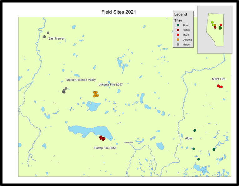
Figure 1. ArcMap of field sites located in northern Alberta. East Mercer harvest sites created in 2009-2010. Mercer-Harmon Valley harvest sites created in 2010. Utikuma fire sites created in 2011. Flattop fire sites created in 2011. Alpac harvest sites created in 2009-2012. M024 fire created in 2009. Map created by Rosanise Odell.
Plot Layout
The sites were separated into three areas: reference, disturbance and island. Each area was assigned 2 plots, one bordering a different area (edge) and the other not bordering the another area (interior). At the plots six transect lines were strewn out at 0, 60, 120, 180, 240 and 300 degrees, declinating the compasses for each site. The plots were 22.56 meters in diameter (400 metres squared).
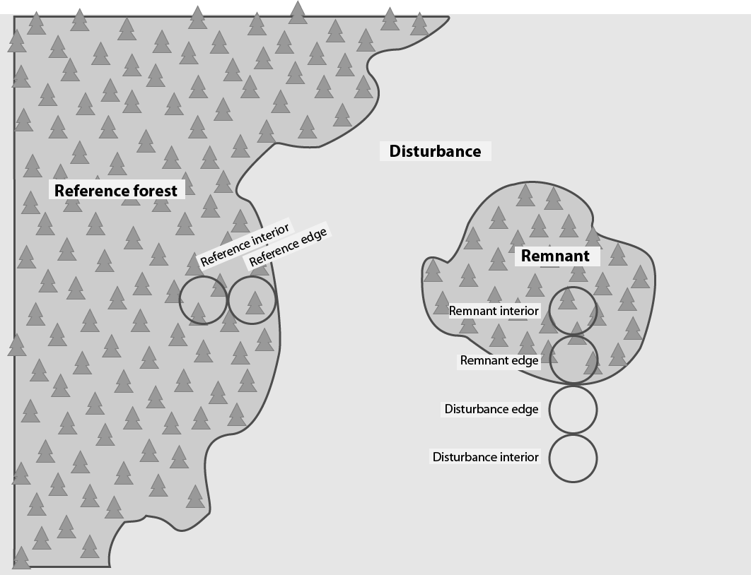
Figure 2. Sketch of a typical field site. Island (Remnant) area contained an interior and edge plot. Disturbance area (either fire or harvest) contained an interior and edge plot. Reference (used as control within larger matrix in same disturbance) contained an interior and edge plot. The centre point of each plot is 30 metres away from the centre of the accompanying plot.

Figure 3. Line-intercept method transect setup. At each plot 6 transect lines were strewn out at 0, 60, 120, 180, 240 and 300 degrees, declinated for each location. Each transect line was 11.28 metres in length, meaning the length of two transects back to back equaled the diametre of the plot (22.56 metres). These transect lines served as the basis for whether a log would be counted or not.
Coarse Woody Debris Collection Criteria
All coarse woody debris ≥ 7.5 cm and > 1 meter long that crosses the transect at any point will be recorded and measured, then assigned a decay class and the species will be identified (if possible). Decay class will be determined sing the 5-category class system based upon Pyle and Brown (1998). Coarse woody debris (CWD) includes down, dead tree and shrub boles, large limbs and other woody pieces. CWD that was angled at >45 were not counted as downed woody debris. Stumps rooted in the ground, bark not attached to a log, roots below the collar and very decomposed logs reduced to slightly elevated ‘humps’ on the ground without structural integrity were excluded from the survey. Standing dead tree information was gathered through typical forest inventory methods, walking around to the dead trees within the same plot, assigning a decay class, recording DBH and attempting to identify to the best of our abilities. Standing dead trees >9.1 DBH were included in this portion of the study.
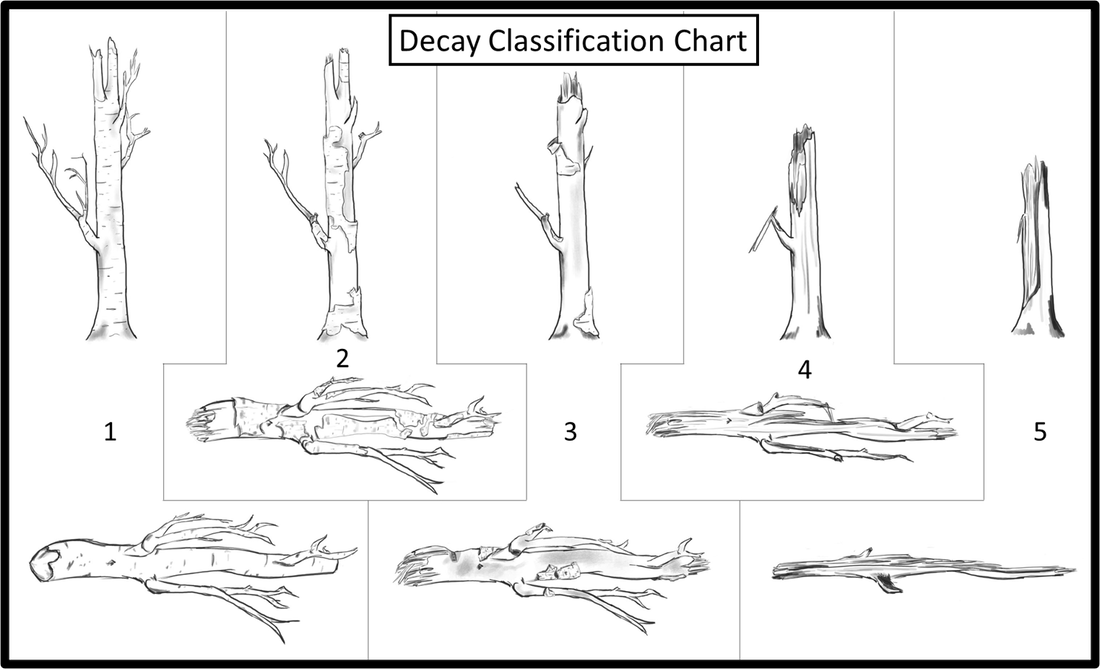
Figure 4. Decay classification chart of standing and downed coarse woody debris. Decay class 1: bark firmly attached, round and solid shape and fine branches remain. Decay class 2: bark present but decayed and not firmly attached, round and solid shape, some fine branches remain yet decayed. Decay class 3: bark generally absent unless Betula spp., round and firm shape, no fine branches left but larger branches still intact. Decay class 4: bark absent, oval or flatten shape that is no longer solid, no fine branches and larger branches not firmly attached. Decay class 5: bark absent, flat heap with no structural integrity, no large or fine branches. Sketch drawn by Lana Mrochuk.
Plot Photos
Photo Gallery 1. Pictures from field work May-August 2021.
